Dolpa (locally pronounced as Dolpo) besides being the largest district in Nepal, covering an area of 5.36% of the country’s total land is renowned for its amazing natural beauty, unique religion, and warm-hearted people. Bordered towards the north and northeast with the Tibet Autonomous Region, China Mustang towards the east, Myagdi, Jajarkot, and Rukum in the south, and Jumla and Mugu towards the west, Dolpa still has its own unique culture.
For centuries, the local people cultivated and grew their own food which consisted of buckwheat, barley, maize, potatoes, etc. The only means of transportation was a yak caravan that carried salt from Tibet to the southern plain in exchange for food grains and commodities. The region was only accessible by foot and the trail meandered through the high passes of Mustang, Dhorpatan region, Rukum and Jajarkot until the operation of an airport.
The airport, located at Juphal, has irregular flights from Nepalgunj. Recently, Nepal Army completed a rural track that connects Dolpa with Dunai (the headquarters of the district from the south). The land was restricted to foreign trekkers until 1989.
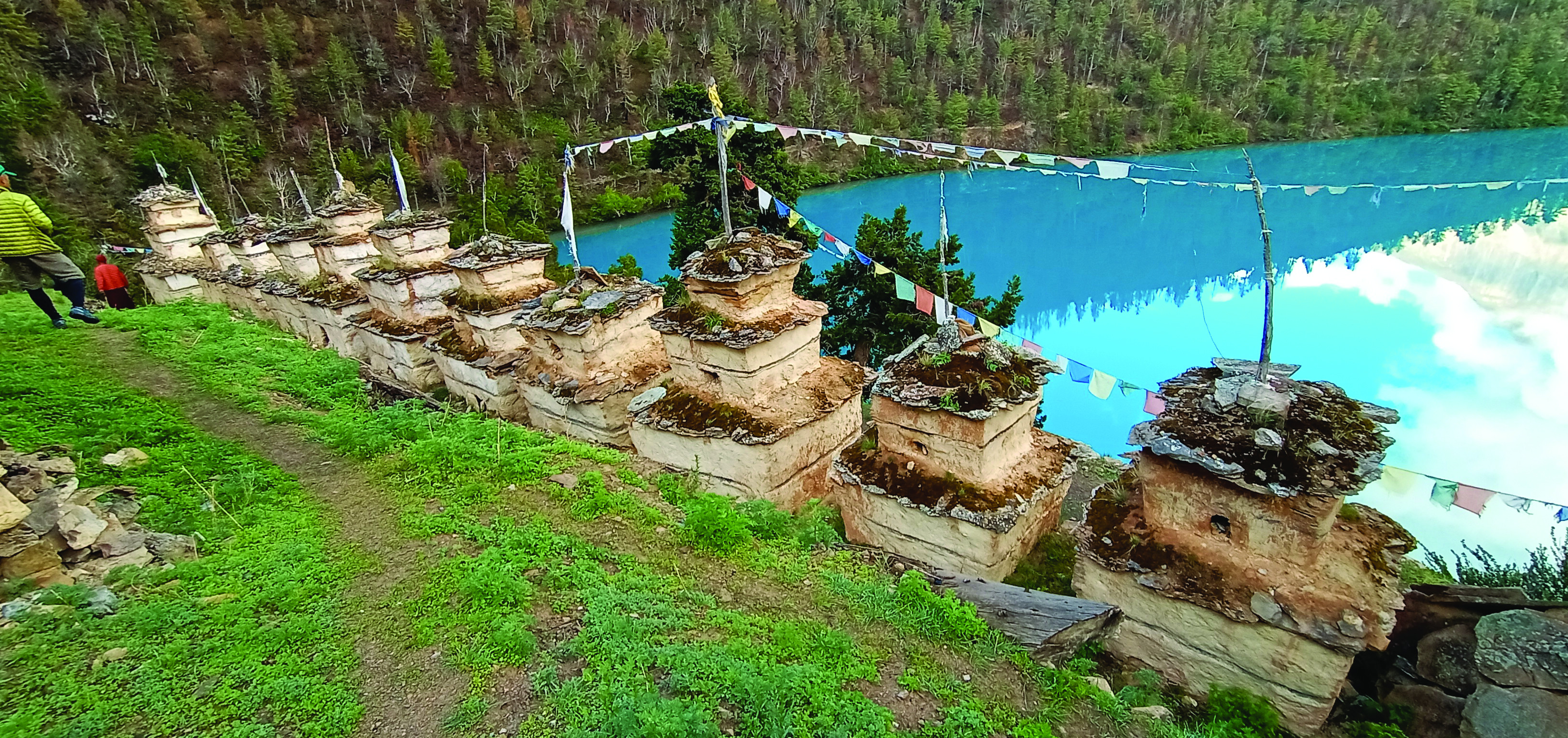
The Phoksundo trek gives you a glimpse into the lives of the local people and their Himalayan lifestyle, against the backdrop of amazing landscapes and crystal clear lake. The blue lake is situated at an altitude of 3,611 meters. The trek passes through the lush green forest, waterfalls, pristine springs, and rivers. Wildflowers bloom during the monsoon and you will get snow clad views of Mt. Kanjirowa and Kang Tai Tonh Himal. You will even encounter centuries-old chortens and Bon monasteries at different villages.
Phoksundo Trek Diary
I set off for the trek with a team of writers and journalists during the last week of June. I had reached Radi two days earlier from Khalanga in the Rukum district while my other team members took a flight from Nepalgunj to Juphal. My journey began after I crossed the suspension bridge at Thuli Bheri River in Radi and passing Tallu Bazar which was a 4.5 hours jeep ride along the Bheri River, Khadang, Kanchhi Bazar in Tipurakot; a small town in Lower Dolpa.
While waiting for my team to arrive, this was the perfect chance to explore Tipurakot. I spent two days visiting Tripura Sundari Temple and walking around the small town. On the third day, I headed towards Dunai by crossing Suligad which is the main gateway to Phoksundo and Upper Dolpa.
I followed the trail beside the army barrack, leaving behind the Bheri River and I finally reached the checkpoint of the Shey Phoksundo National Park. I continued my trek along Phoksundo Lake and reached Kageni. It was a gentle and steady trail with a few ascents and descents. The blue waters of Phoksundo Lake never left me throughout my trek. As I climbed up higher and deeper into the woods, the traill had gentle climbs with the lush green forest through Rhyachi.
The next day of the journey continued till Chunubar passing through Samduwa.
The final day was an exciting morning as we only had a few hours left to reach Phoksundo. The trail was a gentle path for half an hour but then became a steep climb - which was tiring! The day started with an exciting morning as it left a few hours to reach the destination. The path followed the gentle trail for half an hour, then ascended a steep climb. It was a tiring and sweating hike. We saw the beautiful Phoksundo waterfall en route.
Finally, it was there, beautiful Phoksundo lake. The blue Phoksundo lake across beautiful Rigma village at a nearby distance. Yes, it’s now closer, mesmerizing scenes were around us. Shortly, we reached most-awaited Lake.
The lake is 27 kilometers from Suligad. Trekking from Suligad takes two and a half days. It is a comfortable trek. The first day takes around 7 hours and you can overnight at either Santa or Chhepka. The second day is a 7-hour trek to Chunubar and it takes 4 hours to reach Phoksundo on the third day.
Side Trek to Pugmo: A Hidden Village
At an hour’s distance from the main trail at Phoksundo is Pugmo Village (3,200 meters). It is at a distance of 4.3 kilometers, left from Samduwa. The village has 35 houses built with stone, wood, and mud. Bhote communities live in these humble homes. Agriculture and livestock are their major occupations. There is a Bon monastery built during the 15th century known as Namgyal Lakhang.
Fee & Permit: Lower Dolpa trekking permit - US$20 for a week, Shey-Phoksundo National Park - NRs. 3000
Tripura Sundari Temple
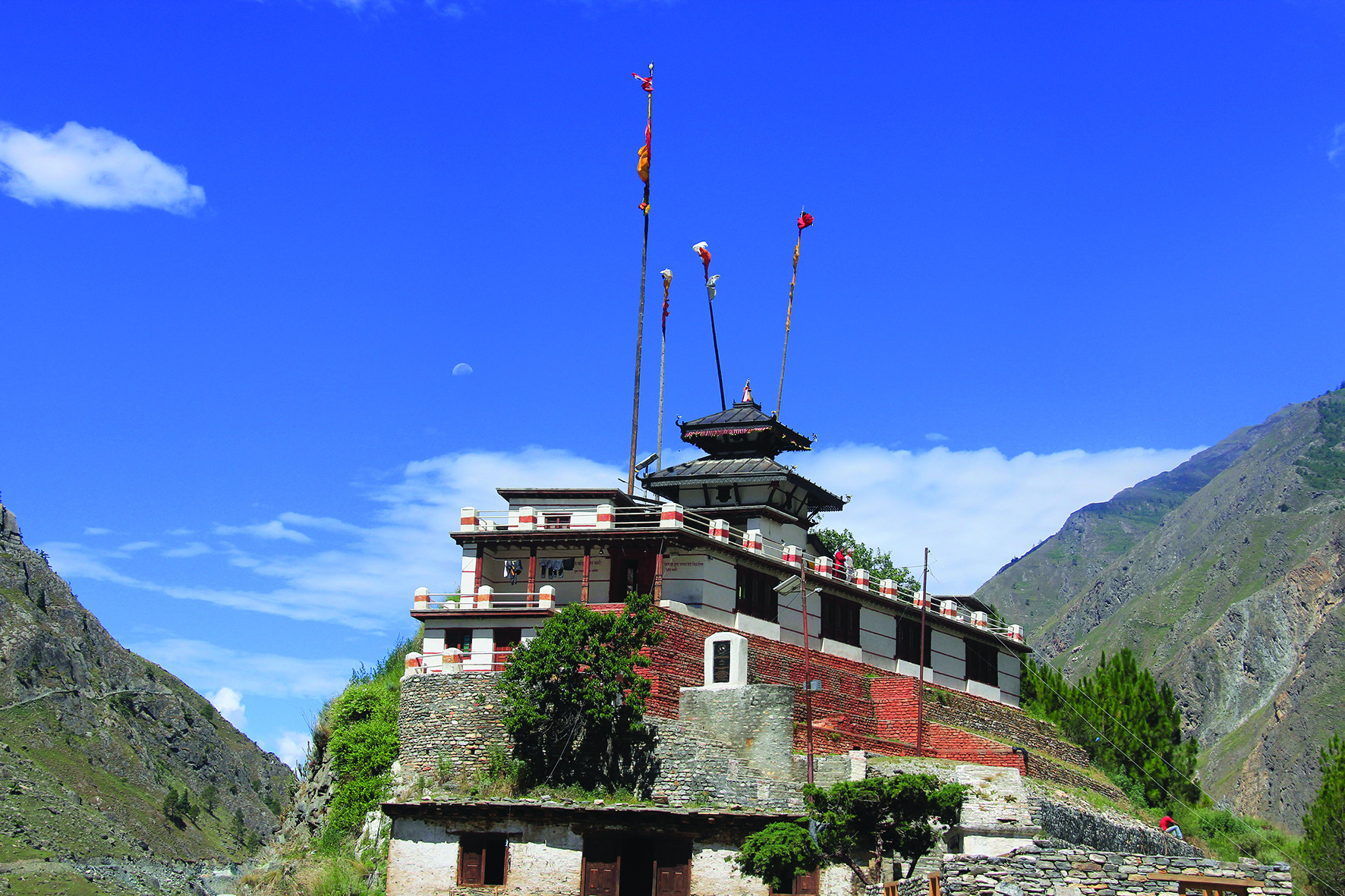
Tripura Sundari is the resident goddess deity of the temple. The temple is situated on a hilltop at an elevation of 2,101 meters near Tipurakot town. The temple is seated on the lap of Mukuteswor Himal, Tamrvani River in the west, Kagmara Himal in the north, and Bahiravi Ganga in the south. At close proximity is a mixed settlement of Kathayat, Brahman, Bista, and Dalit communities.
It is believed that devotee’s wishes are fulfilled when worshipping the goddess. A per legend, there were nine goddess sisters, three of which live here and the rest migrated to Kalikot, Bajura, Salyan, Banke, and Baitadi.
A large number of devotees from Nepal and India visit the temple every year.
Phoksundo lake - Jewels of Dolpo
In Caravan ( Himalaya), a famous 1999 Oscar-nominated film directed by French filmmaker Eric valley has skillfully captured the beauty of turquoise blue colored Phoksundo lake and Dolpo region. The film has portrayed the tough lifestyles of Dolpo people as salt traders.
The total area of the lake is 4.95 sq. km. Its length is 5.93 km, breadth is 1.80 km, and depth of 145 m. The lake is enlisted as a Ramsar site on 23 Sept 2007.
The color of water changes as per the sky color. On the bank of the lake lies centuries-old Bon monastery, Rigma Village, and stupas. A 2.5-hour uphill walk to the viewpoint is worth rewarding to have an entire view of the mesmerizing lake.
Phoksundo lake is a 27 km distance from Suligad. It is reachable in two and a half days on the comfortable trek. On the first day, it takes 6-7 hours and overnight stays at Sangta or Chhepka. The second day, 7-hour trek to Chunubar, and the third day, 4 hours to reach Phoksundo. However, at a faster pace, you could make it in two days.
Yarshagumba
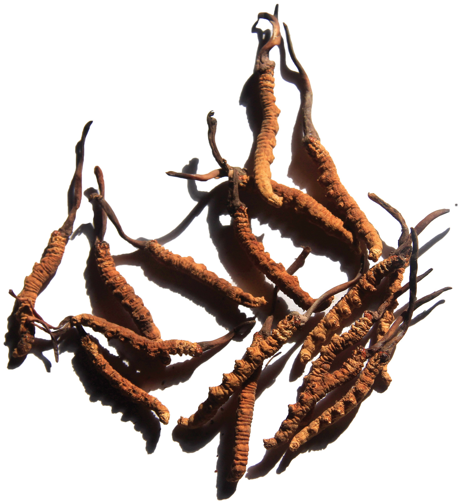
Dolpo is the center of the highly-priced Yarsagumbu (scientific name cordyceps sinensis) a half-plant and insect. In Bhote language, Yarsha meaning monsoon mushroom and gumbu as winter insects. Yarshagumbu is a medicinal herb grown in the highlands above 3500 m to 5200 m. The herbs are believed to help strengthen the immune system and even have aphrodisiacs purposes. Its regular uses help in reducing aging, prevent cancer, and improve kidney functions. Thousands of local people including from the neighboring districts of Rukum and Jajarkot flocks into the highland and passes to harvest these expensive medicinal herbs every year.
Trekking Itineraries
Day 1: Kathmandu to Nepalgunj (By bus or air)
Day 2: Nepalgunj to Juphal, 2475m (By air)
Juphal to Suligad,2075m (30 minutes jeep ride) and trek to Chhepka 2670m
Day 3: Chhepka to Saaijal,3130m (trek for 6 to 7 hours)
Day 4: Saaijal to Phoksundo 3611m (trek for 3 to 4 hours)
Day 5: Phoksundo - Chhepka or Kageni (trek 7 to 8 hours)
Day 6: Kageni - Suligad - Juphal (trek for 5 to 6 hours)
Day 7: Juphal to Nepalgunj (35 minutes by air)
Accessibility
35 minutes flight from Nepalgunj to Juphal and you can either trek or take a ride to Suligad. You can take an 18-hour bus ride from Kathmandu to Radi and then an 8 hours jeep ride.
Travel Advice
● Altitude sickness might occur above 3,000 meters - so take medicine
● Drink plenty of water and walk slowly at a constant pace.
● Respect the local culture and religion.
● Do not spoil the pristine and natural environment.
● If possible, donations to gompas and temples are acceptable.
 Nepal
Nepal
 India
India
 Afghanistan
 Albania
 Algeria
 American Samoa
 Andorra
 Angola
 Anguilla
 Antarctica
 Antigua and Barbuda
 Argentina
 Armenia
 Aruba
Aruba
 Australia
 Austria
 Azerbaijan
 Bahrain
 Bangladesh
 Barbados
 Belarus
 Belgium
 Belize
 Benin
Benin
 Bermuda
 Bhutan
 Bolivia
 Bosnia and Herzegovina
 Botswana
 Brazil
 Brunei
 Bulgaria
 Burkina Faso
 Burundi
 Cambodia
 Cameroon
 Canada
 Cape Verde
 Caribbean Netherlands
 Cayman Islands
 Central African Republic
 Chad
Chad
 Chile
Chile
 China
China
 Christmas Island
 Cocos (Keeling) Islands
 Colombia
 Comoros
 Congo, Democratic Republic of the
 Congo, Republic of the
 Cook Islands
 Costa Rica
 Cote d Ivoire
 Croatia
 Cuba
Cuba
 Curaçao
 Cyprus
 Czech Republic
 Denmark
 Djibouti
 Dominica
 Dominican Republic
 East Timor
 Ecuador
 Egypt
Egypt
 El Salvador
 Equatorial Guinea
 Eritrea
 Estonia
 Ethiopia
 Falkland Islands (Malvinas)
 Faroe Islands
 Federated States of Micronesia
 Fiji
Fiji
 Finland
 France
 French Guiana
 French Polynesia
 Gabon
Gabon
 Georgia
 Germany
 Ghana
Ghana
 Gibraltar
 Greece
 Greenland
 Grenada
 Guadeloupe
 Guam
Guam
 Guatemala
 Guernsey
 Guinea
 Guinea-Bissau
 Guyana
 Haiti
Haiti
 Honduras
 Hong Kong
 Hungary
 Iceland
 Indonesia
 Iran
Iran
 Iraq
Iraq
 Ireland
 Isle of Man
 Israel
 Italy
Italy
 Jamaica
 Japan
Japan
 Jersey
 Jordan
 Kazakhstan
 Kenya
Kenya
 Kiribati
 Korea, North
 Korea, South
 Kuwait
 Kyrgyz Republic
 Laos
Laos
 Latvia
 Lebanon
 Lesotho
 Liberia
 Libya
Libya
 Liechtenstein
 Lithuania
 Luxembourg
 Macao
Macao
 Macedonia
 Madagascar
 Malawi
 Malaysia
 Maldives
 Mali
Mali
 Malta
Malta
 Marshall Islands
 Martinique
 Mauritania
 Mauritius
 Mayotte
 Mexico
Moldova
 Monaco
 Mongolia
 Montenegro
 Montserrat
 Morocco
 Mozambique
 Myanmar (Burma)
 Namibia
 Nauru
Nauru
 Netherlands
 New Caledonia
 New Zealand
 Nicaragua
 Niger
Niger
 Niue
Niue
 Norfolk Island
 Northern Mariana Islands
 Norway
 Oman
Oman
 Pakistan
 Palau
Palau
 Palestine
 Panama
 Papua New Guinea
 Paraguay
 Peru
Peru
 Philippines
 Poland
 Portugal
 Puerto Rico
 Qatar
Qatar
 Reunion
 Romania
 Russia
 Rwanda
 Saint Barthélemy
 Saint Kitts and Nevis
 Saint Lucia
 Saint Martin
 Saint Vincent and the Grenadines
 Samoa
Samoa
 San Marino
 Sao Tome and Principe
 Saudi Arabia
 Senegal
 Serbia and Montenegro
 Seychelles
 Sierra Leone
 Singapore
 Sint Maarten
 Slovakia
 Slovenia
 Solomon Islands
 Somalia
 South Africa
 South Sudan
 Spain
Spain
 Sri Lanka
 St. Helena
 St. Pierre And Miquelon
 Sudan
Sudan
 Suriname
 Swaziland
 Sweden
 Switzerland
 Syria
Syria
 Taiwan
 Tajikistan
 Tanzania
 Thailand
 The Bahamas
 The Gambia
 Togo
Togo
 Tonga
Tonga
 Trinidad and Tobago
 Tunisia
 Turkey
 Turkmenistan
 Turks and Caicos Islands
 Tuvalu
 Uganda
 Ukraine
 United Arab Emirates
 United Kingdom
 United States
 Uruguay
 US Minor Outlying Islands
 Uzbekistan
 Vanuatu
 Vatican City (Holy See)
 Venezuela
 Vietnam
 Virgin Islands (British)
 Virgin Islands(U.S.)
 Wallis and Futuna Islands
 Western Sahara
 Yemen
Yemen
 Yugoslavia
 Zaire
Zaire
 Zambia
 Zimbabwe